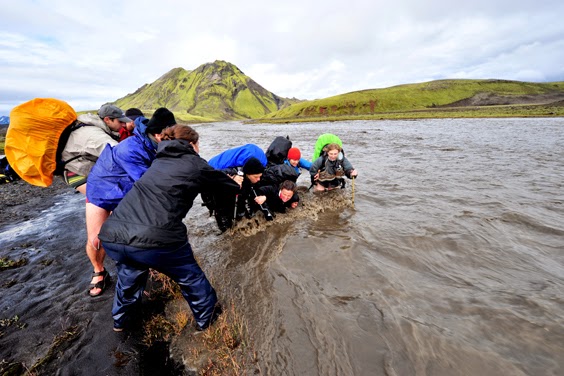
Iceland is a hikers dream. Majority of Iceland is above 1300 feet and the landscape is very diverse. Hikers find large areas full of beautiful mountains, lava fields, lakes, black sands, glaciers, and hot springs. There is no place in the world like Iceland since nature has shaped this unique location.
The Hiking Trails
The Hiking Trails found in Iceland are plentiful and diverse. Individual trails can be read about at tourist information centers located throughout the unique country. Additionally, there are mountain huts available, which allow hikers to book them so their hiking experience can be enhanced.
Most popular hiking trails in Iceland:
1. Landmannalaugar - Þórsmörk (Laugavegur hiking trail)
2. Herðubreiðarlindir-Svartárkot í Bárðardal, Öskjuvegurinn (the Askja hiking trail)
3. Snæfell - Lónsöræfi
4. Hveravellir - Hvítárnes (The old Kjalvegur hiking trail)
5. Skógar - Þórsmörk
Hiking Weather Conditions
During the summertime, it is common for hikers to come from all over to explore the country. The Laugavegur Trail is one of the more popular trails for both locals and tourists. Hikers love the trail because of the diverse landscapes, colorful mountains, rivers, lakes, hot springs, and glaciers that can be seen throughout the trail. Hiking the trail can be difficult if the weather conditions are extreme though. There are six huts along the trail and campsites are available too. Due to environmental concerns and the nature reserves camping in the wild is forbidden.
When in Iceland you have to hike the Laugavegur Trail!
Hiking Tours
If you prefer to be guided through the trails, there are organized hiking tours that you can book to explore the various hiking trails. During the winter months, day and weekend tours are recommended while in the summer months longer tours are recommended.
Alternatively, you have the option of going hiking by yourself. However, when hiking alone you need to make sure that you are cautious. You should have the proper clothing and accessories in addition to letting someone know which trail you plan to hike.
When planning to hike in Iceland visit Safetravel for safety information and to enter your travel plan so you are prepared in the event of an emergency.
Mike, Iceland24
© 2015 Iceland24
Thứ Tư, 5 tháng 8, 2015
Thứ Bảy, 1 tháng 8, 2015
Askja volcano travel guide (Iceland)
For many years now, Askja has been the most popular excursion from Lake Mývatn and one of the top destinations in Iceland.
You will travel through the largest wilderness of Iceland, filled with marvels of nature, driving across lunar landscapes where US-astronauts trained before they ventured to the moon in 1969.
You will see scenes of unforgettable nature and exiting geology. Askja, the huge caldera, is still in the making through bedrock subsidence above a deep-seated magma source. It lies centrally in the mountain massif Dyngjufjöll and is an active centre of a volcanic system.
Askja was not explored until the 19th century. In 1874-1875 there was a series of volcanic eruptions in the system, culminating in a very powerful eruption. Some 2 billion cubic metres of ash and pumice where blown from vents now on the bottom of Lake Öskjuvatn . This 11 sq. km-lake formed within a few years, following the event. It is the deepest lake in Iceland, 220 m. The latest eruption in Askja occurred in the autumn 1961.
We recommend you to walk at the slopes of a 1961-crater. An easy 30-min.-long walk leads you to the explosion crater Víti (Hell) at the rim of Lake Öskjuvatn.
A small, milky and warm lake adorns the crater. Amazingly, it turns into a heaven if you care to take a bath in it. After enjoying the unearthly quietness and bizarre landscape our passengers return to the bus.
Víti is a popular bathing site, but if you intend taking a dip, please be aware that the sloping path is very slippery in wet weather.
Route back to Lake Mývatn, you could make a stop is made at Herðubreiðarlindir where clear water flows from springs in an old lava flow. The springs sustain beautiful vegetation and form small ponds providing conditions for flowering plants and birdlife in the otherwise barren, volcanic landscape. The high bulk of the old sub-glacial volcano (tablemountain) Herðubreið (1682 m) rises about 3 km distant and provides a breathtaking background to this wilderness oasis.
Askja is a 50 km2 caldera in the Dyngjufjoll mountains. The mountains emerged in eruptions under an Ice Age glacier cap. Askja itself was formed, for the most part, at the end of the Ice Age in a major ash eruption which caused the roof of the magma chamber at the heart of the central volcano to subside. Askja is a part of Vatnajökull National Park. The caldera contains several volcanoes, including Víti (explosive volcanic crater). Water has accumulated in the crater, its temperature is variable - it is around 30°C on average.
HOW TO GET THERE?
The road to Askja goes from road 1 to road 901 and onto mountain road F905. Onward to F910 to Drekagil. On this route there are two fords to cross, usually small. From Drekagil goes mountain road F894 (8 km) to the car park at Vikraborgir.
Another option is to go from road 1 to mountain road F88 via Herðubreiðarlindir to Drekagil. On this road ther are fords on the rivers Grafarlandsá and Lindá that need to be crossed. The fords can be difficult or even impassable for small jeeps.
HOW TO DRIVE ON F ROADS?
So what do you have to keep in mind when planning a trip to the highlands?
-You have to be driving a 4x4 vehicle.
-It is strongly advised that people travel together in 2 or more cars.
-You should check information about the conditions of the roads before you start your journey. It is best to call 1777 or check www.road.is.
-Make sure that the F road you plan to travel on is open for traffic.
-Driving outside of the roads in the highlands is strictly forbidden. Actually, driving off road in Iceland is always forbidden!
-Buying a detailed map of the route you will be travelling is much better than using the standard free map you can get at tourist information centers and gas stations. This is not necessary but can be very helpful.
-Whenever possible, try to talk to local people about conditions in the area, such as rangers.
-Tell somebody about your travel plans. You can for example tell the good people over at www.safetravel.is (or just the ranger you talked to before).
-It is good to be prepared for all types of weather as the weather in the highlands can change almost with a blink of an eye.
-Be aware that telephone signals in the highlands are not very stable and you can go for a long while without a mobile connection.
-The emergency number in Iceland is 112. You are able to call it in the highlands, even without a mobile connection.
-There is no petrol station in the highlands so make sure you fill up! :)
THINGS TO CONSIDER WHEN CROSSING THE GLACIER RIVERS
When you cross rivers, make sure that the 4 wheel drive has been engaged before going into the river. Drive very slowly and use the low range if possible. Never switch gears in the middle of the river.
Glacial rivers usually have less water in the mornings. During warm summer days, the flow of the river can increase a lot. Heavy rain can also increase the flow of a river substantially. Be aware that rivers can sometimes not be crossed even if the road is open and you are driving a 4x4 vehicle.
A good rule of thumb regarding glacier rivers is that if you would not want to wade through a river you should not drive through it. Crossing rivers can be a serious matter if people are not careful. Whenever possible, cross with someone with experience in crossing rivers.
Fords over rivers are usually marked and should be easy to spot. Be aware of big rocks that might be under the surface of the water. The worst place to cross is where the water is most calm because that is usually the deepest part of the river. The best way to cross is to follow the torrent diagonally down the river, that way the torrent helps the vehicle over.
If you prefer a guided tour, we recommend a guided tour from Lake Mývatn to the Askja Caldera with this Icelandic company.
You can also make it with a Bus 4x4 from the company Visit Askja. Good price and great adventure!
Peter and Helga
Iceland24
You will travel through the largest wilderness of Iceland, filled with marvels of nature, driving across lunar landscapes where US-astronauts trained before they ventured to the moon in 1969.
You will see scenes of unforgettable nature and exiting geology. Askja, the huge caldera, is still in the making through bedrock subsidence above a deep-seated magma source. It lies centrally in the mountain massif Dyngjufjöll and is an active centre of a volcanic system.
Askja was not explored until the 19th century. In 1874-1875 there was a series of volcanic eruptions in the system, culminating in a very powerful eruption. Some 2 billion cubic metres of ash and pumice where blown from vents now on the bottom of Lake Öskjuvatn . This 11 sq. km-lake formed within a few years, following the event. It is the deepest lake in Iceland, 220 m. The latest eruption in Askja occurred in the autumn 1961.
We recommend you to walk at the slopes of a 1961-crater. An easy 30-min.-long walk leads you to the explosion crater Víti (Hell) at the rim of Lake Öskjuvatn.
A small, milky and warm lake adorns the crater. Amazingly, it turns into a heaven if you care to take a bath in it. After enjoying the unearthly quietness and bizarre landscape our passengers return to the bus.
Víti is a popular bathing site, but if you intend taking a dip, please be aware that the sloping path is very slippery in wet weather.
Route back to Lake Mývatn, you could make a stop is made at Herðubreiðarlindir where clear water flows from springs in an old lava flow. The springs sustain beautiful vegetation and form small ponds providing conditions for flowering plants and birdlife in the otherwise barren, volcanic landscape. The high bulk of the old sub-glacial volcano (tablemountain) Herðubreið (1682 m) rises about 3 km distant and provides a breathtaking background to this wilderness oasis.
Askja is a 50 km2 caldera in the Dyngjufjoll mountains. The mountains emerged in eruptions under an Ice Age glacier cap. Askja itself was formed, for the most part, at the end of the Ice Age in a major ash eruption which caused the roof of the magma chamber at the heart of the central volcano to subside. Askja is a part of Vatnajökull National Park. The caldera contains several volcanoes, including Víti (explosive volcanic crater). Water has accumulated in the crater, its temperature is variable - it is around 30°C on average.
HOW TO GET THERE?
The road to Askja goes from road 1 to road 901 and onto mountain road F905. Onward to F910 to Drekagil. On this route there are two fords to cross, usually small. From Drekagil goes mountain road F894 (8 km) to the car park at Vikraborgir.
Another option is to go from road 1 to mountain road F88 via Herðubreiðarlindir to Drekagil. On this road ther are fords on the rivers Grafarlandsá and Lindá that need to be crossed. The fords can be difficult or even impassable for small jeeps.
HOW TO DRIVE ON F ROADS?
So what do you have to keep in mind when planning a trip to the highlands?
-You have to be driving a 4x4 vehicle.
-It is strongly advised that people travel together in 2 or more cars.
-You should check information about the conditions of the roads before you start your journey. It is best to call 1777 or check www.road.is.
-Make sure that the F road you plan to travel on is open for traffic.
-Driving outside of the roads in the highlands is strictly forbidden. Actually, driving off road in Iceland is always forbidden!
-Buying a detailed map of the route you will be travelling is much better than using the standard free map you can get at tourist information centers and gas stations. This is not necessary but can be very helpful.
-Whenever possible, try to talk to local people about conditions in the area, such as rangers.
-Tell somebody about your travel plans. You can for example tell the good people over at www.safetravel.is (or just the ranger you talked to before).
-It is good to be prepared for all types of weather as the weather in the highlands can change almost with a blink of an eye.
-Be aware that telephone signals in the highlands are not very stable and you can go for a long while without a mobile connection.
-The emergency number in Iceland is 112. You are able to call it in the highlands, even without a mobile connection.
-There is no petrol station in the highlands so make sure you fill up! :)
THINGS TO CONSIDER WHEN CROSSING THE GLACIER RIVERS
When you cross rivers, make sure that the 4 wheel drive has been engaged before going into the river. Drive very slowly and use the low range if possible. Never switch gears in the middle of the river.
Glacial rivers usually have less water in the mornings. During warm summer days, the flow of the river can increase a lot. Heavy rain can also increase the flow of a river substantially. Be aware that rivers can sometimes not be crossed even if the road is open and you are driving a 4x4 vehicle.
A good rule of thumb regarding glacier rivers is that if you would not want to wade through a river you should not drive through it. Crossing rivers can be a serious matter if people are not careful. Whenever possible, cross with someone with experience in crossing rivers.
Fords over rivers are usually marked and should be easy to spot. Be aware of big rocks that might be under the surface of the water. The worst place to cross is where the water is most calm because that is usually the deepest part of the river. The best way to cross is to follow the torrent diagonally down the river, that way the torrent helps the vehicle over.
If you prefer a guided tour, we recommend a guided tour from Lake Mývatn to the Askja Caldera with this Icelandic company.
You can also make it with a Bus 4x4 from the company Visit Askja. Good price and great adventure!
Peter and Helga
Iceland24
Thứ Bảy, 25 tháng 7, 2015
Lofthellir in North Iceland: Natural Ice Sculptures in a 3,500 year old lava cave
In the far north of Iceland lies a weird but beautiful world of ice and darkness. Enter Cave Lofthellir. Here, the underground boasts the greatest natural ice sculptures currently known in an Icelandic lava cave.
Lofthellir is a 3,500 year old lava cave that extends around 370 meters long and boasts formations that will leave you in awe. You can choose whether you want to start the tour from Akureyri or the Lake Myvatn area.
To get to the cave, you’ll drive to an area a mere 45 minute drive from Lake Myvatn. You’ll cross the unique volcano Hverfell, through the crater row of Lúdentarborgir to the roots of Mt. Hvannfell. After a 30 minute or so walk across a lava field, filled with unusual rock and landscape formations, you’ll arrive at a ladder made from rope which you’ll descend in order to enter the cave.
You’ll likely be given rubber boots since although it’s likely to be dry on your hike, you’ll need protection for your shoes once you enter the ice cave. Remember, it’ll be very wet inside.
Once you descend the ladder with your weatherproof gear on, you’re greeted with crystal clear ice before you make your way into the core of the cave itself.
After a few shallow chambers, you need to use a rope to get to the larger chambers, pulling yourself up along a slick area of ice. If you’re claustrophobic, then this may not be for you but if not, it’s certainly an adventure. On the way back, I recommend just sliding down the ice holding onto the rope while you do so – it’s one way to feel ten years old again in a split second.
The colors inside the cave are stunning – vibrant and surreal at the same time.
At one point while we were in the main chamber, our guide turned off all the lights and asked us to dim the flashers on our helmuts. Suddenly, we were completely in the dark with the only sound to be heard, a mere drizzle of water from an icicle above.
We sat quiet for many minutes listening to that soft drizzle and not uttering a word – silence meets serenity. It was a magical experience and something I’d recommend doing even if your guide doesn’t call for it.
Note: I did it with Visit Askja (info@visitaskja.com), a personalized adventure tour company that specializes in trips. All opinions expressed here are my own. I’d recommend taking one or more of their tours when you’re in the north of the country.
This tour is not recommended or suitable for young children, people with claustrophobia or people that are not in reasonable physical condition. There is ice and water on the floor of the cave and the temperature inside the cave is around 0°C.
Iceland24
© 2015 Iceland24
You’ll likely be given rubber boots since although it’s likely to be dry on your hike, you’ll need protection for your shoes once you enter the ice cave. Remember, it’ll be very wet inside.
Once you descend the ladder with your weatherproof gear on, you’re greeted with crystal clear ice before you make your way into the core of the cave itself.
The colors inside the cave are stunning – vibrant and surreal at the same time.
We sat quiet for many minutes listening to that soft drizzle and not uttering a word – silence meets serenity. It was a magical experience and something I’d recommend doing even if your guide doesn’t call for it.
They have free hotel pick-up and departure time is 09:30am. This tour takes around 4-5 hours and the longest hiking time is 2x25 minutes.
This tour is not recommended or suitable for young children, people with claustrophobia or people that are not in reasonable physical condition. There is ice and water on the floor of the cave and the temperature inside the cave is around 0°C.
© 2015 Iceland24
Nhãn:
3,
500,
Akureyri,
cave,
excursions,
iceland,
icelandic,
lake,
lava,
loftheillir,
Lofthellir,
Myvatn,
North,
old,
tour,
years
Thứ Tư, 22 tháng 7, 2015
Dettifoss waterfall travel guide, Iceland - Hiking trails at Dettifoss (west and east)
Falling 45 m with a width of 100 m, Dettifoss is reputed to be the most powerful waterfall in Europe. Visitors generally approach Dettifoss on the west side of the River Jökulsá where the road through Hólssandur is better. However, there are plans to improve the road on the east side. Please take care whichever route you chose.
On the eastern bank, the footpath down to the falls is extremely rough and a number of accidents have occurred when visitors have strayed from the track. The grassy slopes on the western bank become extremely slippery when they are wet.
Selfoss is a smaller waterfall a little way upstream with a drop of 10 m. There are easy paths from Dettifoss, which allow a pleasant 1 km walk.
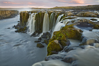
Below Dettifoss, the Hafragilsfoss waterfall cascades 27 m into a deep canyon. It is best to drive to Hafragilsfoss, which is located in an environment that is geologically and historically as fascinating as Dettifoss.
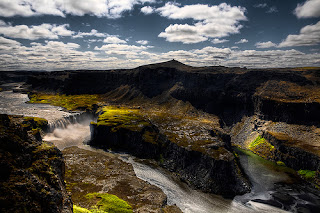
Some years ago, plans were proposed to harness the hydroelectric potential of the canyon, but they were scrapped when the lava strata in the area were found to be too porous for a reservoir. On the east bank of the canyon, near Hafragilsfoss, the river has cut through a crater row named Randarhólar to expose a volcano's lava pipe in the cliff wall
How to get there
Road 864 (east)
Road 864 goes from road 1 to Dettifoss on the east side. This is a gravel road and driving speed depends on road conditions each time. Road 864 is closed during winter time due to snow or wet conditions (muddy road) and does not open until early summer (end of May). Distances on road 864: Road 1 - Dettifoss: 32 km
Road 862 (west)
Road 862 is on the west side of river Jökulsá. Road 862, from Dettifoss south to road 1, on the west river bank, is a new, paved road which is passable for all vehicles. The road is not in service every day during the winter time and is often closed during snowy periods. Distances on road 862: Dettifoss - road 1: ~ 20 km; Dettifoss - Mývatn: ~ 50 km
Hiking trails at Dettifoss (west bank)
The numbers of the hiking paths are in accordance to the number of the paths on the hiking map. Note that at crossroads out in the field these numbers are not at sign posts.
D-1 Dettifoss
Distance: 1,5 km (back and forth)
Walking time: 0.5 -1 hr
Starting point: Dettifoss parking area
Route difficulty: Easy route (blue)
Dettifoss is the most powerful waterfall in Europe. Its enormous power can be felt if you lay your hand on a rock close to the waterfall, it vibrates! Slowly the river digs its way through the waterfall´s edge and each year Dettifoss moves half a meter to the south. From the car park to Dettifoss is a 1 km walk (one way). It is possible to go the same way back.
Warning: The spray from the waterfall goes mostly to the west side of the riverbank, over stone platforms and hiking trails. The area close to the waterfall is therefore really wet, paths can be slippery and visitors have to take special care. During winter time and frost periods heavy piles of ice can form and visitors should not go close to the rim of the canyon.
D-2 Dettifoss and Selfoss
Distance: 2,5 km (circle)
Walking time: 1hr
Starting point: Dettifoss parking area
Route difficulty: Easy route (blue)
Contrasting landscape is one of the main characteristics of Jökulsárgljúfur. This trail reveals the most powerful waterfall in Europe, Dettifoss, against the humble and beautifully shaped Selfoss waterfall. From the parking area to Dettifoss is a 1 km walk (one way). It is possible to go the same way back. However, it is interesting to keep on south, along the riverbank towards Selfoss and then go the more westerly route back to the parking area and close the circle.
D-3 Hafragil lowland
Distance: 9 km (circle)
Walking time: 3 hrs
Starting point: A small parking area east of Hafragil Route
difficulty: Difficult route (black)
Warning: Steep trail, large boulders, risk of falling rocks.
The area in and surrounding Hafragil lowland contains the most difficult but also the most facinating hiking trails in Jökulsárgljúfur and caution should be exercised. The route to the Hafragil lowland starts at a small car park by the turn off to Hafragil waterfall. From there you go east towards the river and you approach the lowland via Sanddalur. There is a fixed rope to help you down a rocky section.
Next you have to descend a steep and rocky slope and then the walk continues past the majestic Hafragil waterfall and through a rocky landslide along a small cove, Fossvogur, under a vertical rock face. This trail is not for people afraid of heights. The route back up takes you into the Hafragil gorge, following sheep tracks up the slope. When up at the rim you head south and follow the Hafragil gorge on the west side until back at the small car park.
Hiking trails at Dettifoss (east bank)
Hafragilsfoss
Distance: 0,5 km (back and forth)
Walking time: 30 minutes
Starting point: Hafragilsfoss parking area
Route difficulty: Challenging route (red)
From Hafragilsfoss parking area is a short walk to Sjónnípa, the crater where an ancient volcano's feeding dyke can be seen. From there is a great view over Hafragilsfoss waterfall as well as the river gorge. This is the deepest and most terrifying part of the gorge, which is around 100m high in the area. People are not adviced to go down to the lowland by the waterfall.
Hafragilsfoss - Dettifoss - Hafragilsfoss
Distance: 5km (back and forth)
Walking time: 1,5 – 2 hours
Starting point: Hafragilsfoss parking area
Route difficulty: Challenging route (red)
A parked path leads from Hafragilsfoss waterfall, along the river gorge and to the Dettifoss parking area. This hike offers a great view over the river gorge.
2 days trip HIKE
Hiking up along the Jökulsárgljúfur canyon, from the luxuriant Ásbyrgi to the barren but magnificent environment around Dettifoss, is a unique experience for every hiker. The diversity of the landscape is unique and captures the eye at every footprint: tremendous gorges, quiet ponds, clear springs, rough river, luxuriant forests and bare gravel plains.
Here is a hiking map of Jökulsárgljúfur: [pdf 1.8 MB]
Route description
It takes two days to hike between Ásbyrgi and Dettifoss and normally lodged in Vesturdalur (Hljóðaklettar). The route can be walked in both directions (start ingeither in Ásbyrgi or Dettifoss). In Jökulsárgljúfur it is only allowed to camp at the official campsites in Ásbyrgi, Vesturdalur and at Dettifoss (a small campsite with few facilities).
Accommodation
On the route there are no cabins and it is only allowed to camp on the park campsites. In Vesturdalur there is a beautiful camp site. There are toilets and running, cold water, but no shower facilities. Please contact the rangers before camping. At Dettifoss there is a small camping area, only intended for hikers. The area is just north of the parking lot. There is no running water at the campsite, but rangers bring fresh water to the site every day. Please use the water spaerly.
If you prefer a guided tour to Dettifoss, we recommend you this company.
Johanna, Iceland24
Selfoss is a smaller waterfall a little way upstream with a drop of 10 m. There are easy paths from Dettifoss, which allow a pleasant 1 km walk.
![]() |
| Selfoss waterfall |
![]() |
| Hafragilsfoss waterfall |
How to get there
Road 864 (east)
Road 864 goes from road 1 to Dettifoss on the east side. This is a gravel road and driving speed depends on road conditions each time. Road 864 is closed during winter time due to snow or wet conditions (muddy road) and does not open until early summer (end of May). Distances on road 864: Road 1 - Dettifoss: 32 km
Road 862 (west)
Road 862 is on the west side of river Jökulsá. Road 862, from Dettifoss south to road 1, on the west river bank, is a new, paved road which is passable for all vehicles. The road is not in service every day during the winter time and is often closed during snowy periods. Distances on road 862: Dettifoss - road 1: ~ 20 km; Dettifoss - Mývatn: ~ 50 km
Hiking trails at Dettifoss (west bank)
The numbers of the hiking paths are in accordance to the number of the paths on the hiking map. Note that at crossroads out in the field these numbers are not at sign posts.
D-1 Dettifoss
Distance: 1,5 km (back and forth)
Walking time: 0.5 -1 hr
Starting point: Dettifoss parking area
Route difficulty: Easy route (blue)
Dettifoss is the most powerful waterfall in Europe. Its enormous power can be felt if you lay your hand on a rock close to the waterfall, it vibrates! Slowly the river digs its way through the waterfall´s edge and each year Dettifoss moves half a meter to the south. From the car park to Dettifoss is a 1 km walk (one way). It is possible to go the same way back.
Warning: The spray from the waterfall goes mostly to the west side of the riverbank, over stone platforms and hiking trails. The area close to the waterfall is therefore really wet, paths can be slippery and visitors have to take special care. During winter time and frost periods heavy piles of ice can form and visitors should not go close to the rim of the canyon.
D-2 Dettifoss and Selfoss
Distance: 2,5 km (circle)
Walking time: 1hr
Starting point: Dettifoss parking area
Route difficulty: Easy route (blue)
Contrasting landscape is one of the main characteristics of Jökulsárgljúfur. This trail reveals the most powerful waterfall in Europe, Dettifoss, against the humble and beautifully shaped Selfoss waterfall. From the parking area to Dettifoss is a 1 km walk (one way). It is possible to go the same way back. However, it is interesting to keep on south, along the riverbank towards Selfoss and then go the more westerly route back to the parking area and close the circle.
D-3 Hafragil lowland
Distance: 9 km (circle)
Walking time: 3 hrs
Starting point: A small parking area east of Hafragil Route
difficulty: Difficult route (black)
Warning: Steep trail, large boulders, risk of falling rocks.
The area in and surrounding Hafragil lowland contains the most difficult but also the most facinating hiking trails in Jökulsárgljúfur and caution should be exercised. The route to the Hafragil lowland starts at a small car park by the turn off to Hafragil waterfall. From there you go east towards the river and you approach the lowland via Sanddalur. There is a fixed rope to help you down a rocky section.
Next you have to descend a steep and rocky slope and then the walk continues past the majestic Hafragil waterfall and through a rocky landslide along a small cove, Fossvogur, under a vertical rock face. This trail is not for people afraid of heights. The route back up takes you into the Hafragil gorge, following sheep tracks up the slope. When up at the rim you head south and follow the Hafragil gorge on the west side until back at the small car park.
Hiking trails at Dettifoss (east bank)
Hafragilsfoss
Distance: 0,5 km (back and forth)
Walking time: 30 minutes
Starting point: Hafragilsfoss parking area
Route difficulty: Challenging route (red)
From Hafragilsfoss parking area is a short walk to Sjónnípa, the crater where an ancient volcano's feeding dyke can be seen. From there is a great view over Hafragilsfoss waterfall as well as the river gorge. This is the deepest and most terrifying part of the gorge, which is around 100m high in the area. People are not adviced to go down to the lowland by the waterfall.
Hafragilsfoss - Dettifoss - Hafragilsfoss
Distance: 5km (back and forth)
Walking time: 1,5 – 2 hours
Starting point: Hafragilsfoss parking area
Route difficulty: Challenging route (red)
A parked path leads from Hafragilsfoss waterfall, along the river gorge and to the Dettifoss parking area. This hike offers a great view over the river gorge.
A hike from Ásbyrgi to Dettifoss
Hiking up along the Jökulsárgljúfur canyon, from the luxuriant Ásbyrgi to the barren but magnificent environment around Dettifoss, is a unique experience for every hiker. The diversity of the landscape is unique and captures the eye at every footprint: tremendous gorges, quiet ponds, clear springs, rough river, luxuriant forests and bare gravel plains.
Distances:
- Ásbyrgi - Dettifoss, total: 32 km (shortest way)
- Ásbyrgi - Vesturdalur: 12 km or 13.6 km (see route description)
- Vesturdalur - Hólmatungur: 8 km
- Hólmatungur - Dettifoss (along Hafragil): 11.5 km
Hiking map
Here is a hiking map of Jökulsárgljúfur: [pdf 1.8 MB]
Route description
It takes two days to hike between Ásbyrgi and Dettifoss and normally lodged in Vesturdalur (Hljóðaklettar). The route can be walked in both directions (start ingeither in Ásbyrgi or Dettifoss). In Jökulsárgljúfur it is only allowed to camp at the official campsites in Ásbyrgi, Vesturdalur and at Dettifoss (a small campsite with few facilities).
From Ásbyrgi to Vesturdalur there are two paths to choose from: One is to follow the rim of Ásbyrgi, and go south along Klappir and Kvíar, just over 12 km. The other route is to go the easterly path, closer to the river, but that route is 13,6 km long. Both routes start at the Visitor Centre in Ásbyrgi.
From the Visitor Centre, there are two ways to access the rim of Ásbyrgi. An easier way is to go east over the golf course and turn south at the intersection east of the golf course. From there the path goes up the lowest part of the cliff. A more difficult way is to go directly south from the Visitor Centre, towards the intersection at Tófugjá. There, turn east and go up the cliff, where there is a rope for support. It is not recommended to go this way if people have a heavy burden. Up at Tófugjá it is possible to choose which way to go to Vesturdalur (along the rim of Ásbyrgi or along the Jökulsá river).
The route between Vesturdalur and Hólmatungur is about 8 km. The only river that has to be waded during the hike, Stallá, is at this section. Stallá is a spring river that flows into the Jökulsá river. The river is shallow and cold, but wading restores tired legs and makes the trip more memorable.
From Hólmatungur there is roughly a 10 km hike south to Dettifoss, if you go into the Hafragil lowland (black route). If you go along the Hafragil ravine the route is 11,5 km. It is not recommended for people with a heavy burden to go down to the lowland. In that case, hikers are advised to go to the campsite at Dettifoss, ease the burden and then explore the lowland.
Accommodation
On the route there are no cabins and it is only allowed to camp on the park campsites. In Vesturdalur there is a beautiful camp site. There are toilets and running, cold water, but no shower facilities. Please contact the rangers before camping. At Dettifoss there is a small camping area, only intended for hikers. The area is just north of the parking lot. There is no running water at the campsite, but rangers bring fresh water to the site every day. Please use the water spaerly.
Drinking water
- Between Ásbyrgi and Vesturdalur there are no streams or springs to take water from. Hikers have to carry all fluids with them.
- In Vestudalur there is running water in the toilet buildings. It is not recommended to drink water from the spring river due to high traffic of people in the area during the summer.
- In Hólmatungur there are a lot of streams from which is safe to drink water.
- Between Hólmatungur and Dettifoss the only spring river is down in Hafragil.
- At Dettifoss there is no running water. Park rangers carry water in tanks to the campground. Hikers are kindly requested to moderate the use of that water.
Obstacles on the route
The trail is mostly easy. The main obstacles on the route are:
- Tófugjá in Ásbyrgi is the way that goes up the rock wall of Ásbyrgi canyon. There is a ladder and rope for support. You can choose another way to get up to the rim. See route description.
- Stallá is the only river that has to be waded. It is shallow and cold but not a major obstacle for hikers.
- Hafragil lowland is the most difficult trail in Jökulsárgljúfur but also the most magnificent. People who carry heavy burdens, are advised not to go down to the lowland, as the path is really narrow in some areas. In Sanddalur the trail is really steep and there is a rope for support to go up/down. Furthermore, the trail goes along large boulders and there is a danger of falling rocks. For those who carry heavy burdens and want to explore the lowland it is better to go all the way to the campsite at Dettifoss, leave the luggage there and then walk back down to the lowland. Those who are afraid of heights are also not advised to go this route.
Travel opportunities
The trail from Ásbyrgi to Dettifoss is a one-way route. Hikers need to have plans to get back from the endpoint. There are two companies that offer regular transport between Ásbyrgi and Dettifoss, SBA and Fjallasýn. SBA offers daily tours between Dettifoss and Ásbyrgi from the 18th of June to the end of August. For more information, visit the SBA website. On reauest, the company Fjallasýn offers transport and/or guided tours between Ásbyrgi and Dettifoss. For more information visit the Fjallasýn website. The school-bus driver Guðmundur Þórarinsson also offers service to hikers and tourist, tel: 892-8928.
If you prefer a guided tour to Dettifoss, we recommend you this company.
Johanna, Iceland24
Nhãn:
862,
864,
canyon,
Dettifoss,
Hafragil,
Hafragilsfoss,
Hólmatungur,
Hólssandur,
Jökulsárgljúfur,
Mývatn,
Road862,
Road864,
Selfoss,
Vatnajökulsþjóðgarður,
Vesturdalur
Thứ Tư, 15 tháng 7, 2015
The Golden Circle - A best of Iceland in one day
The Golden Circle is Iceland's most popular sightseeing tour - and for good reason! In one day you‘ll get to see a magnificent waterfall, the world's oldest parliament and a hot spring area where the famous Geysir resides.
South from here is the religious centre of Skálholt, where Iceland’s last Catholic bishop was assassinated in 1550; while travelling northeast takes you past the spa town of Laugarvatn to Geysir, the original hot blowhole that has lent its name to similar vents worldwide, before sealed roads end on the edge of Iceland’s barren interior at Gullfoss’ thundering twin cataracts.
The property includes the Þingvellir National Park and the remains of the Althing itself: fragments of around 50 booths built from turf and stone. Remains from the 10th century are thought to be buried underground. The site also includes remains of agricultural use from the 18th and 19th centuries. The park shows evidence of the way the landscape was husbanded over 1,000 years.
Camping in Þingvellir
Camping is only permitted in two areas in the National Park. At Leirar, which is within a 5 minutes walking distance from the Information Center, and in Vatnskot, by lake Þingvallavatn. At Leirar there are four camping grounds: Fagrabrekka, Syðri-Leirar, Hvannabrekka and Nyrðri-Leirar. The Vatnskot camp ground is situated at an abandoned farm site by the lake.
Geysir
Geysir, sometimes known as The Great Geysir, is a geyser in southwestern Iceland. It was the first geyser described in a printed source and the first known to modern Europeans.
The English word geyser (a spouting hot spring) derives from Geysir. The name Geysir itself is derived from the Icelandic verb geysa, "to gush", the verb from Old Norse. Geysir lies in the Haukadalur valley on the slopes of Laugarfjall hill, which is also the home to Strokkur geyser about 50 metres south.
Eruptions at Geysir can hurl boiling water up to 70 metres in the air. However, eruptions may be infrequent, and have in the past stopped altogether for years at a time.
Iceland24: Iceland: Golden Circle Tour
The name Golden Circle might be a tourist-industry tag, but it’s also apt, as this broad circuit east from Reykjavík covers many of Iceland’s best-known features and touches on the root of much of its history. The key area is Þingvellir, whose dramatic and geologically unstable rift valley marks where the Icelandic state sprang into being in Viking times.
Þingvellir National Park
Þingvellir (Thingvellir) is the National Park where the Althing, an open-air assembly representing the whole of Iceland, was established in 930 and continued to meet until 1798. Over two weeks a year, the assembly set laws - seen as a covenant between free men - and settled disputes. The Althing has deep historical and symbolic associations for the people of Iceland.
Diving is permitted in two submerged rifts in the Park, Silfra and Davíðsgjá. Silfra is one of the best spots for diving in Iceland and many people find the rift unique on an international scale
Camping is only permitted in two areas in the National Park. At Leirar, which is within a 5 minutes walking distance from the Information Center, and in Vatnskot, by lake Þingvallavatn. At Leirar there are four camping grounds: Fagrabrekka, Syðri-Leirar, Hvannabrekka and Nyrðri-Leirar. The Vatnskot camp ground is situated at an abandoned farm site by the lake.
Geysir
Geysir, sometimes known as The Great Geysir, is a geyser in southwestern Iceland. It was the first geyser described in a printed source and the first known to modern Europeans.
The English word geyser (a spouting hot spring) derives from Geysir. The name Geysir itself is derived from the Icelandic verb geysa, "to gush", the verb from Old Norse. Geysir lies in the Haukadalur valley on the slopes of Laugarfjall hill, which is also the home to Strokkur geyser about 50 metres south.
Eruptions at Geysir can hurl boiling water up to 70 metres in the air. However, eruptions may be infrequent, and have in the past stopped altogether for years at a time.
Gullfoss waterfall
Gullfoss is actually two separate waterfalls, the upper one has a drop of 11 metres and the lower one 21 metres. The rock of the river bed was formed during an interglacial period.
Water flows over Gullfoss at an average rate of 109 cubic metres per second. The heaviest floods have recorded a flow of 2000 cubic metres per second. During the summer the flow is 130 cubic metres per second, which would take only 3 seconds to fill this building. People were eager to exploit the power potential of Gullfoss and many plans for hydroelectric developments on the river Hvítá have been proposed.
Everyone that visits Iceland cannot miss the Golden Circle tour. But the ultimate question is whether you should visit the Golden Circle with a tour company, or self drive the Golden Circle in one day yourself? I highly recommend doing the latter.
What kind of rental car do I need in Iceland?
Depending on the time of year you go, and what your travel plans are, you should be fine just getting a small sedan.
If you are heading there in winter (November – March) you may want to consider picking up a 4×4. This is because some roads can be closed and the roads very icy/snowy. Just check the Iceland road conditions on this official website before you head out.
How to get there
There are several different ways to start the Golden Circle, including of course the option to drive clockwise or anti-clockwise. Here's a map for reference.
Generally it is better to drive clockwise and to begin by taking Route #1 (east) in the direction Vík, but just to the edge of Reykjavík, then turning north (left) onto the 431 and 435.
Johanna & Petrea, Iceland24
July 2015
Đăng ký:
Bài đăng (Atom)