Nowhere on earth is the junction between the European and American tectonic plates in the Earth’s crust as clear as on the
Reykjanes peninsula in the southwest, and at
Þingvellir: the plates diverge here by as much as 2 cm per year. But the gap is constantly being filled, as volcanoes have been erupting regularly throughout Iceland’s history.
The boundaries of this area are drawn at the glacial lagoon
Jokulsarlon in the East, and fishing and ferry town Thorlakshofn in the West. Towns, villages, places of interest and recreation are mentioned above and below.
The South is both densely and sparsely populated. Between the town Hofn and the river Markarfljot are vast alluvial or outwash plains, lava fields and narrow strips of lowlands, which limit agricultural activities, but the western part contains the largest and fertile agricultural area of the country and a few townships.
The landscapes of the lowland and highland areas contain many of the most interesting and beautiful spots of the country. The southern central highlands boast of the largest glaciers, most active and largest volcanoes and eruptive fissures, rhyolite intrusions and hyaloclastite mountains. There are many very active geothermal areas in the mountains and lowlands between the middle of the area all the way to the western boundaries. One of the two main seismic areas of the country streches from Mt Hekla across town Hveragerdi to the end of the southwest
peninsula Reykjanes.
Must do and see in South Iceland1. Thingvellir National ParkÞingvellir (Icelandic "Þing": parliament, "vellir": plains) is a place in the southwest of Iceland near the peninsula of Reykjanes and the Hengill volcanic area.
It is famous for two reasons:
a) As one of the most important places in Icelandic history. In the year 930 the Alþingi, one of the oldest parliamentary institutions of the world, was founded. The Alþingi met yearly, where the Lawspeaker recited the law to all of the gathered people and decided disputes as well. In the year 999 or 1000 the Lawspeaker Þorgeir Ljósvetningagoði made Christianity the official religion of Iceland. After the conversion it is said that, upon returning from the Alþingi, Þorgeir then threw his statues of the old Norse gods into the waterfall that is now named Goðafoss ("Waterfall of the Gods"). At this historical place, the independence of the Republic of Iceland was proclaimed on June 17, 1944.
b) As a national park (since 1928) because of the special tectonic and volcanic environment. The continental drift can be clearly seen in the cracks or faults which are traversing the region, the biggest one, Almannagjá, being a veritable canyon. This causes also the often measurable earthquakes in the area. Þingvellir is situated on the northern shore of Þingvallavatn, the biggest lake of Iceland. The river Öxará traverses the national park and is forming a waterfall at the Almannagjá, called Öxaráfoss Together with the waterfall Gullfoss and the geysirs of Haukadalur, Þingvellir is part of the most famous sights of Iceland, the Golden Circle.
Þingvellir is a designated UNESCO World Heritag Site
Thingvellir, 50 km (31 miles) to the east of Reykjavík, is the national shrine of Iceland. Icelands most historic site, and one of its most beautiful places, it is also part of The Golden Circle tour. The oldest existing parliament in the world first met here in AD930. The Alþing met here every year to enact laws, including the law passed in AD1000 to introduce Christianity into the island. It has always been the focal point for the country, and whenever a major event is to be celebrated, thousands of people come here. At the celebration of the 1,100th anniversary of the first settlement in 1974, more than 60,000 people packed into Thingvellir.
Nearby Lögberg is the cliff overlooking the place where the Alþing (assembly) met, and speakers stood to address the gatherings from this point. Nearby is Drekkingarhylur (The Drowning Pool), where mothers of illegitimate children were drowned. It is sited in the river Öxará in Almannagjá, a lava gorge, which with the Öxarárfoss waterfall, is an impressive sight.
Peningagjá (The Money Chasm) is a deep fissure filled with crystal clear spring water; people throw coins into it from the bridge that lies across. The coins give off strange reflections as they drop through the water, it is said that if you can follow the coin all the way down until it comes to rest on the bottom, your wish will come true. Scubadiving and snorkeling in wet suits is becoming increasingly popular here.
The lake is part of the Þingvellir National Park. The volcanic origin of the islands in the lake is clearly visible. The fissures around it - the famous Almannagjá is the biggest of them - indicate that here the tectonic plates of Europe and The Americas are in a conflict. In this lake, the large quantity of sulfur and salt, the lake is extremely light and the water seems to be in less weight than other lakes.
2. Jökulsárlón Glacier lagoon Check our article about
Jökulsárlón Glacier lagoonThe main lagoon measures about 7 square miles (20 km2) and until 1932 was covered in thick glacial ice. Then the glacier started to retreat, and nowadays more than 300 feet (100 m) of ice breaks away each year to reshape the lagoon and fill it with spectacular icebergs.
The lagoon is open to the sea and so contains a mixture of salt and freshwater, giving it a unique blue-green color. There are hundreds of seals here in the winter and the lagoon supports many species of fish including krill, herring, trout and, occasionally, salmon.
3. Gullfoss Waterfall
Gullfoss is actually two separate waterfalls, the upper one has a drop of 11 metres and the lower one 21 metres. The rock of the river bed was formed during an interglacial period.
Water flows over Gullfoss at an average rate of 109 cubic metres per second. The heaviest floods have recorded a flow of 2000 cubic metres per second. During the summer the flow is 130 cubic metres per second, which would take only 3 seconds to fill this building. People were eager to exploit the power potential of Gullfoss and many plans for hydroelectric developments on the river Hvítá have been proposed.
Check the article call "
Iceland's favorite Waterfalls"
4. The great GeysirOne of the greatest natural attractions of Iceland and part of the famous "Golden Circle Tour", The Great Geysir, or Stori-Geysir, has been dormant since 1916 when it suddenly ceased to spout. It came to life only once in 1935, and as quickly went back to sleep. Since then its repose has sporadically been disturbed by the dumping of tons of carbolic soap powder into its seething orifice in order to tickle it to spout.

It is not exactly known when Geysir was created. It is believed that it came into existence around the end of the 13th century when a series of strong earthquakes, accompanied by a devastating eruption of Mt. Hekla, hit Haukadalur, the geothermal valley where Geysir is located. What is known is that it spouted regularly every third hour or so up to the beginning of the 19th century and thereafter progressively at much longer intervals until it completely stopped in 1916. Whether its silence is eternal or temporary no one knows. When it was alive and shooting, it could thunderously blast a spectacular jet of superheated water and steam into the air as high as 60 to 80 meters according to different sources. Its opening is 18 meters wide and its chamber 20 meters deep.
One reason for cessation is believed to be the accumulated rocks and foreign objects thrown into it by thousands of tourists throughout the years. Though definitely damaging, this however could not be the only reason for its dormancy. The Great Geysir was among the most notable geysers in the world, such as those in Yellowstone Park, New Zealand and North Iceland. The English word "geyser" is derived from the Icelandic word "geysir" which means gusher. Though the Great Geysir itself is now more or less inactive, the area surrounding it is geothermically very active with many smaller hot springs.
The attraction of the area is now Strokkur (The Churn), another geyser 100 meters south of the Great Geysir, which erupts at regular intervals every 10 minutes or so and its white column of boiling water can reach as high as 30 meters. The whole area is a geothermal park sitting on top of a vast boiling cauldron. Belching sulphurous mud pots of unusual colors, hissing steam vents, hot and cold springs, warm streams, and primitive plants can all be found here.
A short distance away to the west stands the small Laugarfjall Mountain with a panoramic view overlooking the Geysir area. King Christian IX of Denmark visited the area in 1874 and by the foot of the mountain are the rocks where he leaned while his hosts tried to impress and amuse him by boiling eggs in the hot springs. The rocks are now called Konungssteinar ("The King's Stones").
5. Eyjafjallajokull Glacier Eyjafjallajökull is one of the smaller ice caps of Iceland, situated to the north of Skógar and to the west of Mýrdalsjökull. The ice cap covers the caldera of a volcano with a summit elevation of 1,651 metres (5,417 ft).
It derives its name from the Island Archipelago off the south coast, The Vestman Islands. This mountain massif is actually the result of continuous eruptions during thousands of years and a vast crater on top has probably been active a few times during historic times of this country. The only documented eruptions took place in 920, 1612, which was seen all the way to the northern part of the country, and during the period 1821-23. The latter two eruptions caused at least damage to property by glacier bursts (floods) and ash fall.
The latter caused a three hours’ flood, covering the wide valley floor north of the mountain. Before and around the turn of the last century, an increased earthquake activity and escaping gasses were watched closely. This volcano, and many others, is within the most active 50 miles wide zone of the country.
The volcano has erupted relatively frequently since the last glacial period, most recently in 2010.
The icecap on top is the sixth largest of the country, and is relatively easily accessible from the mountain saddle Fimmvorduhals, the farms Seljavellir and Mork, and from the north at Stakkolt and Langanes. Nowadays it is not considered a great deed or too much of an adventure to conquer the glaciers in specially equipped and modified jeeps or other vehicles.
Two aircraft have crashed on the icecap. In 1952 an American rescue plane, with five on board, went down and only one body was found on location. The other four obviously had survived and walked away, not to be found during the next few years. Twelve years later, another body was found and a wedding ring of another. The glacier tongue delivered the remaining three bodies in the summer of 1966. Scrap and pieces from the plane have been appearing gradually in and by the sides of the glacier. In 1975, an American couple crashed and lost their lives.
6. The Vatnajókull regionIn the magnificent nature of the Vatnajokull Region, everyone can find enjoyable recreation. There are options for adventure trips as well as relaxing trips; for summer as well as winter; for children as well as the elderly and everything in between. Tourists in the Vatnajokull Region can choose from a variety of activities, scenic views, historical sites and points of interest.
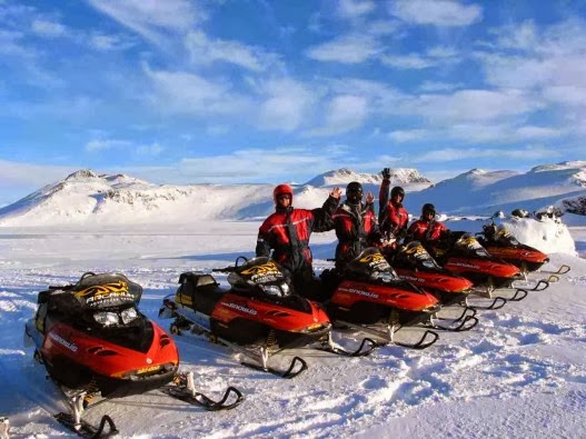
You can choose from a variety of outdoor activities such as golf, bird watching, fishing, horseback riding, boat tours, kayak tours, mountaineering, trekking, ice climb, glacier walk, kayak tours, boat tours, snowmobile tours, super jeep tours or ATV tours.
Visit the Thorbergur Center of Culture or the Art gallery in Höfn. Take a swim in the geothermal-heated swimming pool in the town of Höfn or relax in the geothermal hot tubs in Hoffell. Here below you can search for options based on type or location.
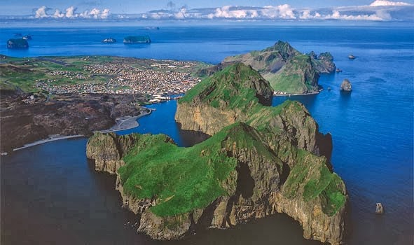
7. Westman IslandsWestman Islands is one of the best kept secrets in Iceland and you haven't seen Iceland until you have visited Westman Islands. Westman Islands is one of the wonders of nature, surrounded by mountains, islands, volcanoes and seabirds. Westman Islands also has one of the most beautiful and extraordinary 18 hole golf course in the world.
A common mistake that visitors make when coming to Westman Islands is that they stop for one day. We haven't met a tourist yet that didn't want to stay longer so our advise to you is, spend at least two days and then you might be able to experience all the great things about Westman Islands.

The island is surrounded by rocky mountains, volcano and 14 other small islands which are all in different size and shape. In Westman Island you can find one of the most beautiful and extraordinary golf course in the world, if you like golf you can't let this one pass you by. To enjoy what the island has to offer, we recommend that you take a guided tour around the island and you should take the boat tour, that is truly a spectacular experience where you sail around the islands, into caves, by other small islands/skerries and experience the buzzing birdlife that is in Westman Islands and who knows maybe you will see a flock of killer whales swimming by. Furthermore we recommend that you take a hike :) and walk to Skansinn, Eldfell, Hamar or just walk up the next mountain, you can also rent a scooter if you want to cover more ground.
8. LandmannalaugarThe Landmannalaugar area is a popular tourist destination and hiking hub in Iceland's highlands. The area displays a number of unusual geological elements, like the multicolored rhyolite mountains and expansive lava fields, not far from the service center. The many mountains in the surrounding area display a wide spectrum of colors including pink, brown, green, yellow, blue, purple, black, and white. Two of the most popular mountains among hikers are Bláhnjúkur (meaning "blue peak") and Brennisteinsalda (meaning "sulphur wave").
Tourists visit the area from June through late September, after which time the road is closed. A mountain lodge, in operation since 1951, can accommodate 78 people and has basic amenities. It is located centrally near natural geothermal hot springs, also popular with tourists.
Check our article about
Landmannalaugar9. Climbing HeklaTrip Difficulty 3 out of 5 possibleMt. Hekla is undeniably Iceland’s most famous mountain. It is the second most active volcano in Iceland and has erupted frequently in historic times. Last eruption occurred in February 2000. The mountain towers over South Iceland at roughly 1500 meters. The height changes due to movements of the earth crusts and seismic movements. For hundreds of years the mountain was believed to be the gateway to hell and no one dared climbing it. Until, Eggert Ólafsson, a famous Icelandic biologist, decided to throw caution to the wind and succeeded in summiting the mountain in the summer of 1750.

Since then hiking to the top of Mt. Hekla has become a popular route. The terrain is rough lava fields and then ice and snow as we get closer to the peak. It usually takes 3-4 hours to get to the top and there you´ll get your reward. The view from the top of Mt. Hekla is wide and beautiful; you can see all of Fjallabak mountains, up to Vatnajökull glacier (Europe’s biggest glacier) not to mention all the evidence of recent and longstanding volcanic activity.
10. DyrhólaeyDyrhólaey is located at latitude 63° 27 N and longitude 19° 06 W. The Icelandic name ending on -ey might indicate that it is an island, which it is not; its a promontory, reaching out into the ocean. It is thought to have been created during a submarine volcanic eruption approximately 80 thousand years ago.
The eruption, which formed Dyrhólaey and the pillars around it (originally parts of it), presumably took place in the same way as other submarine and subglacial eruptions. In the beginning, a major tephra eruption took place and later, when the crater reached the surface of the sea, the lava started to flow and thus ensured its existence. Dyrhólaey is a promontory reaching out into the ocean on the south coast of Iceland. It is the southernmost part of the country and is around 120 m high. Off Dyrhólaey, there are rock pillars, that are unique natural formations.
The roaring Atlantic and its foamy waves wash the black sands at the foot of Dyrhólaey. From there you can enjoy the sight of the varied and fantastic scenery of the Mýrdalur valley, fresh green fields and pastures. Above them, moors and tuff mountains of different shapes, and the mountains of the highland pastures, high and awesome, cut by deep ravines and gorges. Behind them, the white glacier reaches a height of almost 1450 m.
To the west the Vestmannaeyjar archipelago is clearly visible, when visibility is good, and also the mountains Eyjafjöll and the glacier Eyjafjallajökull. Not far off the coast to the west of Dyrhólaey is the Kamburinn, much further out and more to the west is the stack Máfadrangur, where the Gannet colonized a few decades ago.
To the south of the promontory is the stack Lundadrangur with a sizable cave, into which you can go by boat, when the weather is nice and the ocean is calm. To the east is the sheer stack Háidrangur (56 m), which the daredevil Eldeyjar-Hjalti was the first human to climb in 1893, as far as we know. The southernmost part of Dyrhólaey reaching into the sea is called Tóin, and there is the famous opening, which gives it its name Portland in English.. The surroundings are all amazingly beautiful and ever-changing from different viewpoints. A very rich birdlife can be enjoyed, and inquisitive seals are seldom far away.
Few places in the country offer better opportunities for enthusiastic birdwatchers than Dyrhólaey. The various species of seabirds are most prominent in the promontory itself, and not least in the stacks. On some days the rock walls of the promontory and the stacks are almost covered with seabirds.
11. Katla GeoparkKatla Geopark includes geological features of global significance. Over 150 volcanic eruptions have been recorded in the area since the 9th century. The eruptions created the landscape and influenced where people settled. Through the centuries, man and nature have affected the region’s history. The area is constantly changing due to the volcanic activity.
A geopark is defined as a territory, which includes a particular geological heritage and a sustainable territorial development strategy to promote development. It must have clearly defined boundaries and sufficient surface area for true territorial economic development.
The Geopark covers about 9% of Iceland, 9542 km2, and follows the borders of three municipalities, Skaftárhreppur, Mýrdalshreppur and Rangárþing eystra. About 2700 people live within the Geopark. GeologyIceland lies astride the Mid-Atlantic Ridge where tectonic plates move apart from each other, causing a rift zone. A mantle plume exists below the country, centred beneath Vatnajökull ice cap. In South Iceland the interaction of the rift zone and the mantle plume results in complex and diverse volcanic activity. Volcanic activity and its widespread effect on the area’s nature and landscape make Katla Geopark very special.
The Geopark is in the most volcanically active area of Iceland, and the volcanic systems at Eyjafjallajökull, Katla, and Grímsvötn are particularly active. The region is characterised by central volcanoes, eruptive craters and fissures, rootless cones, lava fields, table mountains (tuyas), and hyaloclastite ridges which trend SW-NE, like the rift zone.
Ice caps are prominent in the landscape, topping the highest volcanoes. Outlet glaciers and glacial rivers flow from them and glacial landforms, e.g. moraines and ice-dammed lakes, occur in the area. Large floods, usually glacier outbursts associated with subglacial eruptions, have formed outwash plains in the lowlands. The oldest bedrock in the area is about 2.5 million years old, and can be found at the base of Lómagnúpur, an old sea-cliff (671 m). Other interesting features in the Geopark are fossil-bearing xenoliths, and tephra layers which are useful for dating (tephrochronology).
12. Skaftafell National ParkThe second national park, Skaftafell, established in 1967 (400-500 square kilometres), contains some of the most precious natural pearls of the country. The rugged landscapes, mountains and glaciers, the flora and the fauna have a magnetic influence on the visitors.
In 1984, it was increased in area (1736 square kilometres) including a considerable part of Glacier Vatnajokull. In November 2004 the area of the park was still increased to 4,807 square kilometres. It now comprises the Laki Area as well as about half of Euorpe's largest icecap, Vatnajokull. There are no roads in the park, but a network of trails offers the opportunity for differently extended hikes. The camping grounds are large but it is difficult to hammer the tent pegs into the gravel surface. Among the services rendered in the park are toilets, washing machines, a restaurant, a small shop and a very interesting Visitors Centre.
The park wardens offer regular guided walking tours and daily bus tours tours from the park to the volcanic Laki area and Jokulsarlon as well as the daily schedule. A comprehensive brochure with maps and hiking trails is available at the Visitors' Centre. The distance from the capital is about 340 km.
Guðrún, February 2015
Iceland24