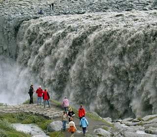
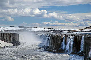
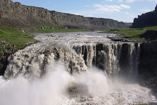
Falling 45 m with a width of 100 m, Dettifoss is reputed to be the most powerful waterfall in Europe. Visitors generally approach Dettifoss on the west side of the River Jökulsá where the road through Hólssandur is better. However, there are plans to improve the road on the east side. Please take care whichever route you chose.
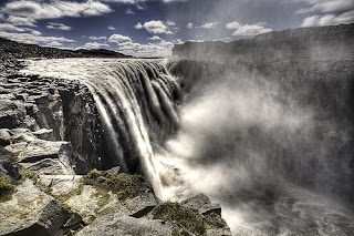
On the eastern bank, the footpath down to the falls is extremely rough and a number of accidents have occurred when visitors have strayed from the track. The grassy slopes on the western bank become extremely slippery when they are wet.
Selfoss is a smaller waterfall a little way upstream with a drop of 10 m. There are easy paths from Dettifoss, which allow a pleasant 1 km walk.
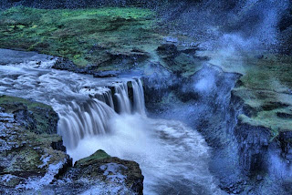
Below Dettifoss, the Hafragilsfoss waterfall cascades 27 m into a deep canyon. It is best to drive to Hafragilsfoss, which is located in an environment that is geologically and historically as fascinating as Dettifoss.
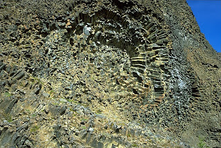
Some years ago, plans were proposed to harness the hydroelectric potential of the canyon, but they were scrapped when the lava strata in the area were found to be too porous for a reservoir. On the east bank of the canyon, near Hafragilsfoss, the river has cut through a crater row named Randarhólar to expose a volcano's lava pipe in the cliff wall
How to get there
Road 864 (east)
Road 864 goes from road 1 to Dettifoss on the east side. This is a gravel road and driving speed depends on road conditions each time. Road 864 is closed during winter time due to snow or wet conditions (muddy road) and does not open until early summer (end of May). Distances on road 864: Road 1 - Dettifoss: 32 km
Road 862 (west)
Road 862 is on the west side of river Jökulsá. Road 862, from Dettifoss south to road 1, on the west river bank, is a new, paved road which is passable for all vehicles. The road is not in service every day during the winter time and is often closed during snowy periods. Distances on road 862: Dettifoss - road 1: ~ 20 km; Dettifoss - Mývatn: ~ 50 km
Hiking trails at Dettifoss (west bank)
The numbers of the hiking paths are in accordance to the number of the paths on the hiking map. Note that at crossroads out in the field these numbers are not at sign posts.
D-1 Dettifoss
Distance: 1,5 km (back and forth)
Walking time: 0.5 -1 hr
Starting point: Dettifoss parking area
Route difficulty: Easy route (blue)
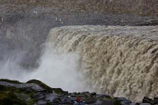
Dettifoss is the most powerful waterfall in Europe. Its enormous power can be felt if you lay your hand on a rock close to the waterfall, it vibrates! Slowly the river digs its way through the waterfall´s edge and each year Dettifoss moves half a meter to the south. From the car park to Dettifoss is a 1 km walk (one way). It is possible to go the same way back.
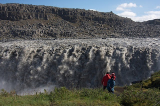
Warning: The spray from the waterfall goes mostly to the west side of the riverbank, over stone platforms and hiking trails. The area close to the waterfall is therefore really wet, paths can be slippery and visitors have to take special care. During winter time and frost periods heavy piles of ice can form and visitors should not go close to the rim of the canyon.
D-2 Dettifoss and Selfoss
Distance: 2,5 km (circle)
Walking time: 1hr
Starting point: Dettifoss parking area
Route difficulty: Easy route (blue)
Contrasting landscape is one of the main characteristics of Jökulsárgljúfur. This trail reveals the most powerful waterfall in Europe, Dettifoss, against the humble and beautifully shaped Selfoss waterfall. From the parking area to Dettifoss is a 1 km walk (one way). It is possible to go the same way back. However, it is interesting to keep on south, along the riverbank towards Selfoss and then go the more westerly route back to the parking area and close the circle.
D-3 Hafragil lowland
Distance: 9 km (circle)
Walking time: 3 hrs
Starting point: A small parking area east of Hafragil Route
difficulty: Difficult route (black)
Warning: Steep trail, large boulders, risk of falling rocks.
The area in and surrounding Hafragil lowland contains the most difficult but also the most facinating hiking trails in Jökulsárgljúfur and caution should be exercised. The route to the Hafragil lowland starts at a small car park by the turn off to Hafragil waterfall. From there you go east towards the river and you approach the lowland via Sanddalur. There is a fixed rope to help you down a rocky section.

Next you have to descend a steep and rocky slope and then the walk continues past the majestic Hafragil waterfall and through a rocky landslide along a small cove, Fossvogur, under a vertical rock face. This trail is not for people afraid of heights. The route back up takes you into the Hafragil gorge, following sheep tracks up the slope. When up at the rim you head south and follow the Hafragil gorge on the west side until back at the small car park.
Hiking trails at Dettifoss (east bank)
Hafragilsfoss
Distance: 0,5 km (back and forth)
Walking time: 30 minutes
Starting point: Hafragilsfoss parking area
Route difficulty: Challenging route (red)
From Hafragilsfoss parking area is a short walk to Sjónnípa, the crater where an ancient volcano's feeding dyke can be seen. From there is a great view over Hafragilsfoss waterfall as well as the river gorge. This is the deepest and most terrifying part of the gorge, which is around 100m high in the area. People are not adviced to go down to the lowland by the waterfall.
Hafragilsfoss - Dettifoss - Hafragilsfoss
Distance: 5km (back and forth)
Walking time: 1,5 – 2 hours
Starting point: Hafragilsfoss parking area
Route difficulty: Challenging route (red)
A parked path leads from Hafragilsfoss waterfall, along the river gorge and to the Dettifoss parking area. This hike offers a great view over the river gorge.
2 days trip HIKE
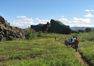
Hiking up along the Jökulsárgljúfur canyon, from the luxuriant Ásbyrgi to the barren but magnificent environment around Dettifoss, is a unique experience for every hiker. The diversity of the landscape is unique and captures the eye at every footprint: tremendous gorges, quiet ponds, clear springs, rough river, luxuriant forests and bare gravel plains.
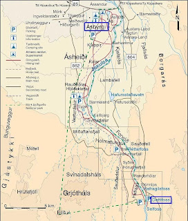
Here is a hiking map of Jökulsárgljúfur: [pdf 1.8 MB]
Route description
It takes two days to hike between Ásbyrgi and Dettifoss and normally lodged in Vesturdalur (Hljóðaklettar). The route can be walked in both directions (start ingeither in Ásbyrgi or Dettifoss). In Jökulsárgljúfur it is only allowed to camp at the official campsites in Ásbyrgi, Vesturdalur and at Dettifoss (a small campsite with few facilities).

Accommodation
On the route there are no cabins and it is only allowed to camp on the park campsites. In Vesturdalur there is a beautiful camp site. There are toilets and running, cold water, but no shower facilities. Please contact the rangers before camping. At Dettifoss there is a small camping area, only intended for hikers. The area is just north of the parking lot. There is no running water at the campsite, but rangers bring fresh water to the site every day. Please use the water spaerly.


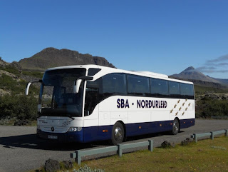
If you prefer a guided tour to Dettifoss, we recommend you this company.
Johanna, Iceland24


Selfoss is a smaller waterfall a little way upstream with a drop of 10 m. There are easy paths from Dettifoss, which allow a pleasant 1 km walk.
 |
| Selfoss waterfall |
 |
| Hafragilsfoss waterfall |
How to get there
Road 864 (east)
Road 864 goes from road 1 to Dettifoss on the east side. This is a gravel road and driving speed depends on road conditions each time. Road 864 is closed during winter time due to snow or wet conditions (muddy road) and does not open until early summer (end of May). Distances on road 864: Road 1 - Dettifoss: 32 km
Road 862 (west)
Road 862 is on the west side of river Jökulsá. Road 862, from Dettifoss south to road 1, on the west river bank, is a new, paved road which is passable for all vehicles. The road is not in service every day during the winter time and is often closed during snowy periods. Distances on road 862: Dettifoss - road 1: ~ 20 km; Dettifoss - Mývatn: ~ 50 km
Hiking trails at Dettifoss (west bank)
The numbers of the hiking paths are in accordance to the number of the paths on the hiking map. Note that at crossroads out in the field these numbers are not at sign posts.
D-1 Dettifoss
Distance: 1,5 km (back and forth)
Walking time: 0.5 -1 hr
Starting point: Dettifoss parking area
Route difficulty: Easy route (blue)
Dettifoss is the most powerful waterfall in Europe. Its enormous power can be felt if you lay your hand on a rock close to the waterfall, it vibrates! Slowly the river digs its way through the waterfall´s edge and each year Dettifoss moves half a meter to the south. From the car park to Dettifoss is a 1 km walk (one way). It is possible to go the same way back.

Warning: The spray from the waterfall goes mostly to the west side of the riverbank, over stone platforms and hiking trails. The area close to the waterfall is therefore really wet, paths can be slippery and visitors have to take special care. During winter time and frost periods heavy piles of ice can form and visitors should not go close to the rim of the canyon.

D-2 Dettifoss and Selfoss
Distance: 2,5 km (circle)
Walking time: 1hr
Starting point: Dettifoss parking area
Route difficulty: Easy route (blue)
Contrasting landscape is one of the main characteristics of Jökulsárgljúfur. This trail reveals the most powerful waterfall in Europe, Dettifoss, against the humble and beautifully shaped Selfoss waterfall. From the parking area to Dettifoss is a 1 km walk (one way). It is possible to go the same way back. However, it is interesting to keep on south, along the riverbank towards Selfoss and then go the more westerly route back to the parking area and close the circle.

D-3 Hafragil lowland
Distance: 9 km (circle)
Walking time: 3 hrs
Starting point: A small parking area east of Hafragil Route
difficulty: Difficult route (black)
Warning: Steep trail, large boulders, risk of falling rocks.
The area in and surrounding Hafragil lowland contains the most difficult but also the most facinating hiking trails in Jökulsárgljúfur and caution should be exercised. The route to the Hafragil lowland starts at a small car park by the turn off to Hafragil waterfall. From there you go east towards the river and you approach the lowland via Sanddalur. There is a fixed rope to help you down a rocky section.
Next you have to descend a steep and rocky slope and then the walk continues past the majestic Hafragil waterfall and through a rocky landslide along a small cove, Fossvogur, under a vertical rock face. This trail is not for people afraid of heights. The route back up takes you into the Hafragil gorge, following sheep tracks up the slope. When up at the rim you head south and follow the Hafragil gorge on the west side until back at the small car park.
Hiking trails at Dettifoss (east bank)
Hafragilsfoss
Distance: 0,5 km (back and forth)
Walking time: 30 minutes
Starting point: Hafragilsfoss parking area
Route difficulty: Challenging route (red)
From Hafragilsfoss parking area is a short walk to Sjónnípa, the crater where an ancient volcano's feeding dyke can be seen. From there is a great view over Hafragilsfoss waterfall as well as the river gorge. This is the deepest and most terrifying part of the gorge, which is around 100m high in the area. People are not adviced to go down to the lowland by the waterfall.

Hafragilsfoss - Dettifoss - Hafragilsfoss
Distance: 5km (back and forth)
Walking time: 1,5 – 2 hours
Starting point: Hafragilsfoss parking area
Route difficulty: Challenging route (red)
A parked path leads from Hafragilsfoss waterfall, along the river gorge and to the Dettifoss parking area. This hike offers a great view over the river gorge.

A hike from Ásbyrgi to Dettifoss
Hiking up along the Jökulsárgljúfur canyon, from the luxuriant Ásbyrgi to the barren but magnificent environment around Dettifoss, is a unique experience for every hiker. The diversity of the landscape is unique and captures the eye at every footprint: tremendous gorges, quiet ponds, clear springs, rough river, luxuriant forests and bare gravel plains.

Distances:
- Ásbyrgi - Dettifoss, total: 32 km (shortest way)
- Ásbyrgi - Vesturdalur: 12 km or 13.6 km (see route description)
- Vesturdalur - Hólmatungur: 8 km
- Hólmatungur - Dettifoss (along Hafragil): 11.5 km
Hiking map
Here is a hiking map of Jökulsárgljúfur: [pdf 1.8 MB]
Route description
It takes two days to hike between Ásbyrgi and Dettifoss and normally lodged in Vesturdalur (Hljóðaklettar). The route can be walked in both directions (start ingeither in Ásbyrgi or Dettifoss). In Jökulsárgljúfur it is only allowed to camp at the official campsites in Ásbyrgi, Vesturdalur and at Dettifoss (a small campsite with few facilities).

From Ásbyrgi to Vesturdalur there are two paths to choose from: One is to follow the rim of Ásbyrgi, and go south along Klappir and Kvíar, just over 12 km. The other route is to go the easterly path, closer to the river, but that route is 13,6 km long. Both routes start at the Visitor Centre in Ásbyrgi.
From the Visitor Centre, there are two ways to access the rim of Ásbyrgi. An easier way is to go east over the golf course and turn south at the intersection east of the golf course. From there the path goes up the lowest part of the cliff. A more difficult way is to go directly south from the Visitor Centre, towards the intersection at Tófugjá. There, turn east and go up the cliff, where there is a rope for support. It is not recommended to go this way if people have a heavy burden. Up at Tófugjá it is possible to choose which way to go to Vesturdalur (along the rim of Ásbyrgi or along the Jökulsá river).

The route between Vesturdalur and Hólmatungur is about 8 km. The only river that has to be waded during the hike, Stallá, is at this section. Stallá is a spring river that flows into the Jökulsá river. The river is shallow and cold, but wading restores tired legs and makes the trip more memorable.
From Hólmatungur there is roughly a 10 km hike south to Dettifoss, if you go into the Hafragil lowland (black route). If you go along the Hafragil ravine the route is 11,5 km. It is not recommended for people with a heavy burden to go down to the lowland. In that case, hikers are advised to go to the campsite at Dettifoss, ease the burden and then explore the lowland.
Accommodation
On the route there are no cabins and it is only allowed to camp on the park campsites. In Vesturdalur there is a beautiful camp site. There are toilets and running, cold water, but no shower facilities. Please contact the rangers before camping. At Dettifoss there is a small camping area, only intended for hikers. The area is just north of the parking lot. There is no running water at the campsite, but rangers bring fresh water to the site every day. Please use the water spaerly.
Drinking water
- Between Ásbyrgi and Vesturdalur there are no streams or springs to take water from. Hikers have to carry all fluids with them.
- In Vestudalur there is running water in the toilet buildings. It is not recommended to drink water from the spring river due to high traffic of people in the area during the summer.
- In Hólmatungur there are a lot of streams from which is safe to drink water.
- Between Hólmatungur and Dettifoss the only spring river is down in Hafragil.
- At Dettifoss there is no running water. Park rangers carry water in tanks to the campground. Hikers are kindly requested to moderate the use of that water.
Obstacles on the route
The trail is mostly easy. The main obstacles on the route are:
- Tófugjá in Ásbyrgi is the way that goes up the rock wall of Ásbyrgi canyon. There is a ladder and rope for support. You can choose another way to get up to the rim. See route description.
- Stallá is the only river that has to be waded. It is shallow and cold but not a major obstacle for hikers.
- Hafragil lowland is the most difficult trail in Jökulsárgljúfur but also the most magnificent. People who carry heavy burdens, are advised not to go down to the lowland, as the path is really narrow in some areas. In Sanddalur the trail is really steep and there is a rope for support to go up/down. Furthermore, the trail goes along large boulders and there is a danger of falling rocks. For those who carry heavy burdens and want to explore the lowland it is better to go all the way to the campsite at Dettifoss, leave the luggage there and then walk back down to the lowland. Those who are afraid of heights are also not advised to go this route.
Travel opportunities
The trail from Ásbyrgi to Dettifoss is a one-way route. Hikers need to have plans to get back from the endpoint. There are two companies that offer regular transport between Ásbyrgi and Dettifoss, SBA and Fjallasýn. SBA offers daily tours between Dettifoss and Ásbyrgi from the 18th of June to the end of August. For more information, visit the SBA website. On reauest, the company Fjallasýn offers transport and/or guided tours between Ásbyrgi and Dettifoss. For more information visit the Fjallasýn website. The school-bus driver Guðmundur Þórarinsson also offers service to hikers and tourist, tel: 892-8928.

If you prefer a guided tour to Dettifoss, we recommend you this company.
Johanna, Iceland24


